Activities related to the Space Industry
SATELLITE ANALYSIS Satellite Analysis AI Solution
One-stop support from satellite image collection to analysis using advanced AI
Ridge-i is a startup that uses satellite imagery and AI to visualize environmental risks such as natural disasters and social activities, with the aim of realizing a new way of living for all of us.
We are a one-stop supplier for all your satellite analysis needs, from new projects to AI-based analysis and tool development.
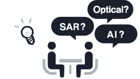
Target problems
- We don't know how to use the ever-increasing variety of satellite products (optical and SAR).
- We need to use satellite imagery to support our business needs.
- We want to contribute to activities related to the SDGs.
- We want to speed up the time-consuming data analysis process.
 What Ridge-i has to offer
- One-stop consultation service for satellite imagery applications.
- Provide high-speed and high-accuracy analysis tools using advanced AI.
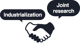
- New venture planning, joint research and development partnerships.
-
One-stop consultation services
-

AI Analysis
-
Partnerships
Please feel free to contact us for more information about satellite imagery applications.
Click herelandslide detection, etc. CASE Use case image analysis from satellite data
-
01
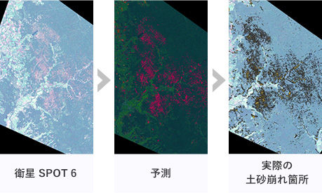
Landslide detection using satellite data and AI
Analysis commissioned by JAXAFast and accurate (Mean IoU >80%) detection of landslide areas caused by the Hokkaido Boryu East Earthquake using Deep Learning
-
02
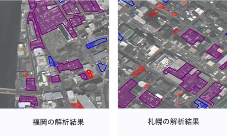
Automatic parking lot detection program
Results of the analysis of satellite data from Fukuoka and Sapporo areas using the newly developed program.
Legend: purple: correct location, blue: undetected location, red: incorrect location -
03
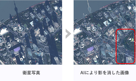
Shadow removal AI
Remove shadows to properly extract geographic features.
-
04
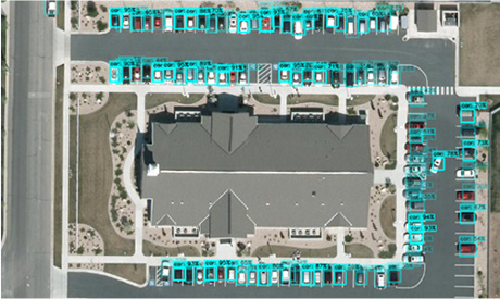
Vehicle detection from aerial photographs
Trained a model for car detection by artificially coarsening aerial 15cm resolution images to 30cm resolution.
High accuracy car detection for satellite images with 30cm resolution(R&D) -
05
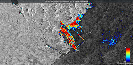
Estimating the location of the heavy oil spill on the island of Mauritius
Heat map image of oil slick based on radar satellite image.
(The figure shows the probability based on publicly available satellite images.) -
06
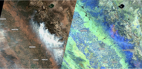
Visualization of California forest fires, showing burn areas hidden by clouds
-
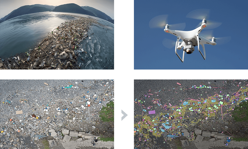
07
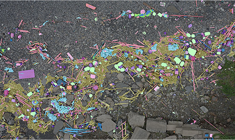
Analyzing the types and amounts of marine debris
Analysis results from drone images of Tsushima Kamitsuki beach captured in July.
PARTICIPATING GROUP Organizations and Awards
Organizations
01 Tellus xData Alliance
Participating in the xData Alliance, an organization that develops and promotes the use of the Tellus satellite data platform, in the area of satellite data utilization (creating new value by combining ground and satellite data).
02 Participated in "Space ICT Promotion Forum" (Ministry of Internal Affairs and Communications)
03 Committee member for space-related projects of the Ministry of Economy, Trade and Industry, Ministry of Internal Affairs and Communications, etc.
Our representative, Mr. Yanagihara, is a member of various committees. He is involved in making proposals for the development of services and next-generation satellites.
- Advisory Committee for the Ministry of Economy, Trade and Industry's "Open and Free Government Satellite Data and Data Utilization Environment Improvement Project.
- Member of the Task Force for the Utilization of 4-D Cyber City, Ministry of Internal Affairs and Communications
- Participated in the experts' meeting of the IT Office, Cabinet Secretariat: "Report on the characteristics of data use in AI systems and points to keep in mind when handling data", etc.
Awards
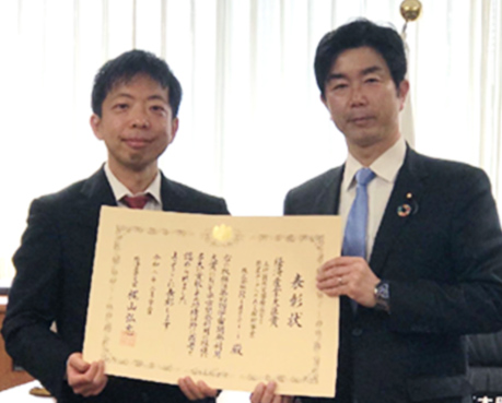
In 2020, we received a prestigious award from the Minister of Economy, Trade and Industry at the 4th Space Utilization Awards sponsored by the Cabinet Office in recognition of our efforts to utilize AI for satellite imagery for disaster prevention.
In 2020, we received the prestigious Minister of Economy, Trade and Industry Award at the 4th Space Utilization Awards held by the Cabinet Office for our efforts in utilizing AI for satellite imagery for disaster prevention.
-
Awarded the Minister of Economy, Trade and Industry Prize at the 4th Space Utilization Awards
-
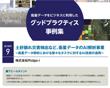
Our case study was published in a collection of case studies issued by the Cabinet Office.
-
Paper accepted for NeurIPS2019 Workshop
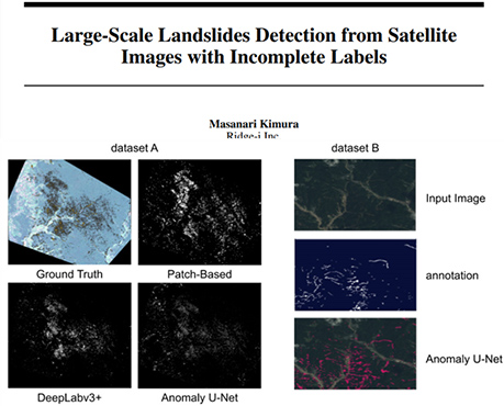
A paper on the detection of landslide areas from large-scale satellite data conducted in collaboration with JAXA
OUTLOOK Deep Learning Technologies and Perspectives in the Space Industry
The role of machine learning/deep learning is to provide the same level of insight as humans from large amounts of data.
To take advantage of this potential, there are two approaches: analyze data that has not been fully exploited yet due to limited human resources, and analyze new, unknown data.
The use of deep learning for space and satellite image data has only just begun in the past few years. In addition, for SAR (Synthetic Aperture Radar), the number of new satellites and observation data with different frequencies is increasing every day. These are just two characteristics of the data that deep learning can help us analyze.
Initially, our activities had a high element of research and development, but thankfully, the market, local authorities, and the government are increasingly appreciating our efforts, and we are accelerating our pace toward future commercialization.
REASON Why does Ridge-i venture into the space domain?
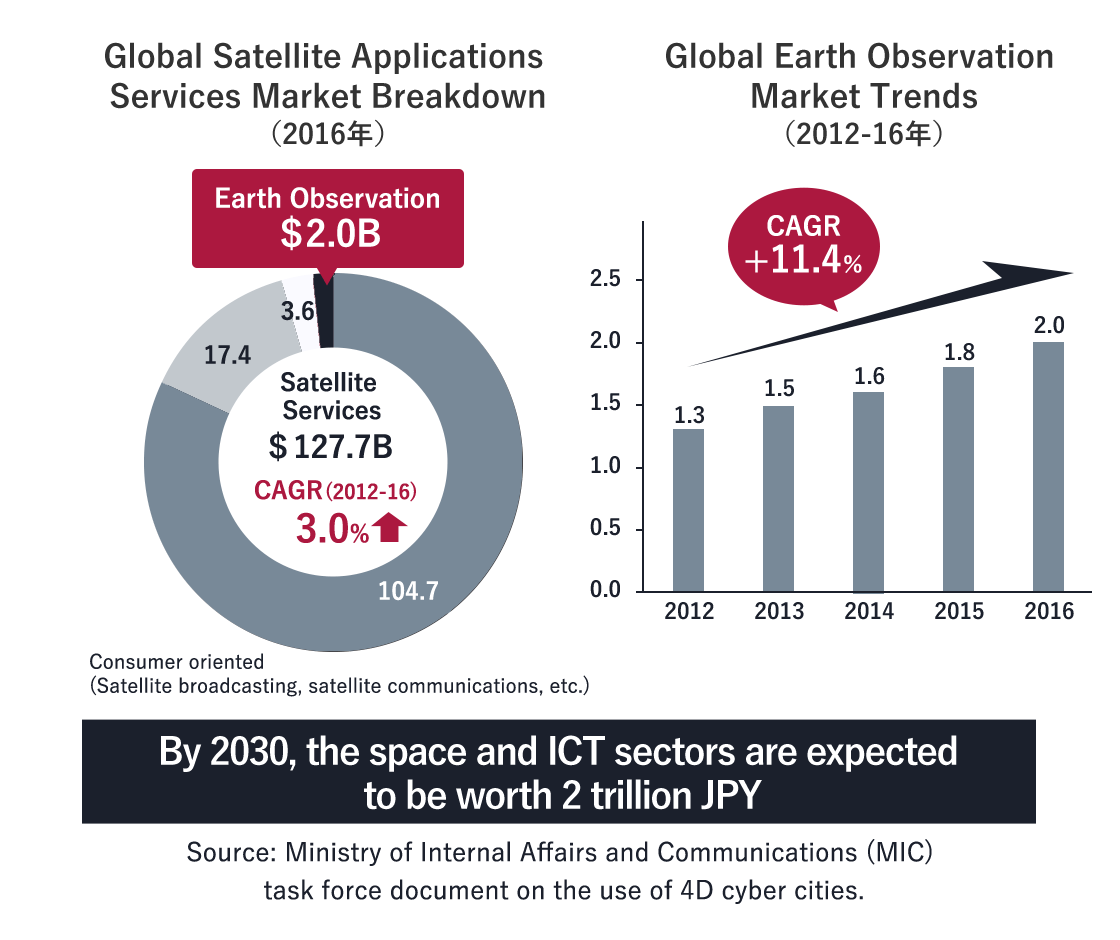
From space-related infrastructure to in-space experiments, the space business is expected to grow on a global scale to a market size of 1 trillion dollars in the next 20 years, more than four times the current size.
We believe that the key elements that will drive the growth of the space industry are:
● Effective use of energy
● Mature remote sensing technology
● Stabilization and cost reduction of rocket launches
● Improvement of space infrastructure (satellite orbit arrangement, space debris, etc.)
● Economic rationality
The space industry has been strongly government-led, but we believe that the availability of satellite data and communication networks will encourage economic rationality, which will accelerate the use of democratic space infrastructure.
The first step for Ridge-i is to use deep learning technology to analyze and provide satellite data (optical, SAR, etc.) in a form that is of interest to the market, thereby stimulating the market and promoting economic rationality. In addition, we have an immediate vision to promote the maturation of remote sensing technology by fully utilizing machine learning and deep learning technologies.Putting technologies such as reinforcement learning on satellites and search vehicles may be useful for autonomous control in very remote and laggy communication environments.
We believe that by using machine learning and deep learning technologies, the space industry will grow much faster than 20 years. In this context, we would like to become the leading company when it comes to the use of AI in the space industry.
APPROACH Ridge-i's Approach to the Space Industry
Challenges hindering the use of satellite data and Ridge-i's countermeasures
-
Issue01
Distributed domain knowledge required for satellite operators
- ・We don't know where to get satellite images of the region, time period, and resolution we want.
- ・Need to bridge the gap between satellite operators. Difficult to automate general purpose operation for high frequency.
-
Issue02
Purchase of satellite imagery is expensive.
- ・Hurdles to purchase and try. In many cases ROI is not viable.
- ・Not "Where is something happening?" but "Where did it happen and what do we need to know about it?". Change detection is impossible.
-
Issue03
High unit price image sales and seed-driven cycle
- ・Applications that have a clear area of interest (i.e., security-related) have the best ROI.
- ・Someone is willing to pay a higher price, but can't sell the same place at a lower price.
-
Countermeasure01
One-stop shop for satellite analysis
- ・Support from satellite data selection and advice to analysis.
-
Measure02
Stimulate needs by selling analysis results
- ・Free distribution of analysis results to stimulate the market
- ・Satellite imagery (big data) x AI: Creation of new use cases
-
Measure03
Achieve a good needs-driven cycle
- ・Shifting to a business model of selling analysis results.
- ・Rapid re-generation and deployment through knowledge and know-how accumulation.
- ・Cooperation with drones and other close domains
We challenge ourselves to realize the cycle of both public and business issues!
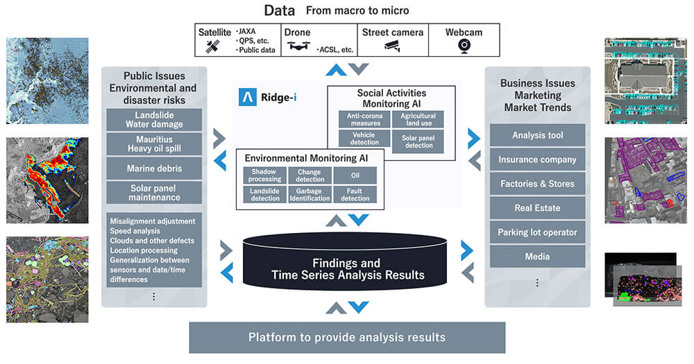
Ridge-i's Eco-Cycle for the Space Industry
The first step is to show that there is a lot of interesting knowledge buried in satellite data that can be used for familiar needs, by actively accumulating and publishing examples of AI-based analysis. From there, we aim to create an eco-cycle in which we can identify more specific needs from the user's perspective, and work with satellite operators to create satellites that meet those needs.
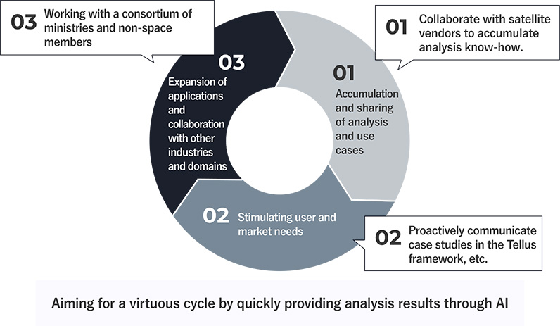
We will set up this eco-cycle early on. By rotating the cycle, we will achieve "cost efficiency through the use of satellites that meet our needs," "low-cost data purchase through the launch of a large number of satellites," and " commercialization through the use of analysis technology as a platform".
In order to build the aforementioned eco-cycle, we will make full use of deep learning, the core of Ridge-i's technology, and accumulate case studies. We will also continue to collaborate with various space/satellite related people and laboratories to promote the utilization of space data.
FUTURE DEPLOYMENTS Future Developments
We regularly acquire images of coastal areas and oceans using satellites and drones, and analyze the increase and decrease of debris, its types, and inflow routes. One-stop service from drone photography to debris analysis reports
First project:Periodic observation service for drifting and floating debris
| Time frame | 1 month |
|---|---|
| Cost | 2 ~ 5M JPY / time |
| Report Contents | Estimated area and statistics for each debris type (9 types) on the target beaches. |
| Expected client |
|
Second project:3D simulations based on satellite and aerial images
Adding value to satellite images by generating fast 3D models. Simulation and VR/AR content creation.
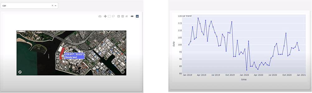
Third project:Global Change Extraction Portal (beta version)
This is a service that visualizes changes over the entire globe in a time-series manner. The conventional model of selling images does not meet the needs of people who want to know where changes have occurred, because they need to specify the location when they purchase. If one wanted to know what happened on Earth, they would need to purchase images of the entire planet (500 million square kilometers, 200 million JPY each), which is extremely expensive.
We will soon be releasing a service to visualize where changes have occurred on the planet, using our own technology and data sources.
As an example, here is a visualization of how the number of parking spaces at Disneyland has changed before and after Corona. We are also planning to add information on land reclamation and land subsidence in the future.