Ridge-i Corporation (Head office: Chiyoda-ku, Tokyo, President: Takashi Yanagihara), a consulting and development company for AI and deep learning technologies, has developed a global change detection service, "GRASP EARTH," which is currently under development and will be available for a limited time. "GRASP EARTH" is available in two types, GRASP EARTH SAR and GRASP EARTH COLOR. Using SAR satellite imagery of the entire world except for some regions and oceans, "GRASP EARTH" displays new buildings in blue and decreasing buildings in red during a specified period. It is also possible to compare the changes with optical images and visually check the changes.
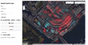
See the example of Tsukiji Market demolition with GRASP EARTH SAR
Here is a comparison of the Tsukiji market in January 2016 and January 2021. If we refer to the articles " Demolition of the Tsukiji Market " and " Asbestos Disposal in the Demolition of the Former Tsukiji Market," we can assume that the red parts of the video show the demolished part of the building, and the blue parts show the isolated curing of the asbestos removal area. The overall reddish color indicates that the demolition has progressed. It is also possible to output a time series of the changes, with time on the horizontal axis and the "building-like index" on the vertical axis.
▼ Screen image of GRASP EARTH SAR
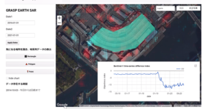
A time-series graph of the index measuring the building's appearance, showing that the index has been declining since February 2019, indicating that the demolition of the building has begun.
▼ Screen image of GRASP EARTH COLOR (comparison using optical images: left 2016, right 2021)
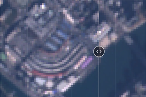
By comparing the optical images of the change points, we can see that the Tsukiji market has been cleanly demolished.
Outline of "GRASP EARTH
GRASP EARTH" is a system that can compare "data of the same quality" and "time series" at any point on the earth.
GRASP EARTH is a web service that is full of the strengths of satellites and can be used easily by anyone without any difficult knowledge.
- GRASP EARTH introduction site: https://sites.google.com/ridge-i.com/grasp-earth/
- Two types of applications, "GRASP EARTH SAR" and "GRASP EARTH COLOR", are provided.
- Operation of the application is 3 steps
- Enter the location where you want to see the change in the "Search places" box at the top of the screen and select the location.
- Set the Date1 and Date2.
- Press "Apply Dates
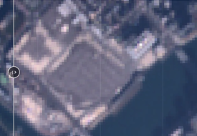
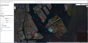
▼GRASP EARTH SAR: Extracting changes in SAR images between two points in time (Tokyo Bay)
Click here for a 30-second tutorial: https://youtu.be/KpzX2KjXhVY
GRASP EARTH COLOR: Compare changes between two time points using optical satellite images
Click here to see how to operate in 30 seconds: https: //youtu.be/6LlxbmAJZVA

Call for "GRASP EARTH" Supporters
We are currently looking for 5 supporters who can give us their impressions and interesting ways to use "GRASP EARTH". If you are interested, please click here to apply.
Application form: https://qr.paps.jp/U7s2
The article was also published in "sorabatake-"!
What is the Global Change Detection Service "GRASP EARTH"? https://sorabatake.jp/19223/
The use cases of "GRASP EARTH" explain the contents that can be read from each case.